
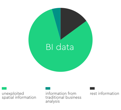
Are you aware that 80% of your BI data contains spatial information, 90% of which remains totally unexploited where the rest 10% is being processed with traditional business analysis systems?
Exploit the spatial component of your data and realize increase in revenue, enhancement of your business organization processes and customer satisfaction.
THE GEOMARKETING CONCEPT
Get greater customer insights by combining Business Intelligence, Demographics & Socioeconomics data to Map Locations
GeoMarketing introduces Location Intelligence in the business process. It can be considered as the 5th P in the Marketing Mix: Process
Find out where are your customers (Visualize Your Customer), what are their demographics and socioeconomic characteristics (Model the Customer), where do they spend their money (Find Customer Needs and Behaviors) and successfully target them (Target Customers)
APPLIED GEOMARKETING
Regardless of the size of your organization or the complexity of your GeoInformatics project, DataGaia, is your valuable partner in the design and implementation of your GeoMarketing needs
Explore a number of GIS applications to solve real business problems: Map your customers (Locate Your Customer), design sales territories that balance workload, sales potential, and driving efficiency (Sales Territory Planning), find the optimal locations for new stores (Site Selection) use your customers location to deliver or enhance a marketing message or service (Location Based Services), determine the service areas of your stores by covering the entire region of interest and avoiding overlapping or cannibalism issues (Stores Service Areas), effectively plan and manage your fleet of vehicles (Logistics) and much more
GEOPROCESSING SERVICE & TOOLS
DataGaia can help you out to embed spatial functionality to your native or third party applications based on Ready-To-Use Geoprocessing Services and/or to use a Geoprocessing set of tools to process geographic and related data
Do you need to see your customers on the map? Apply Geocoding Service to convert their addresses to longitude / latitude coordinates. Do you want to find out the number of people living within 5 minutes distance towards your store? Run a Service Area Geoprocessing Service. Is there a need to route your customers to your stores? Routing Service can help you out. Do you want to deliver your products in the most efficient way in terms of minimizing operating costs and delivery times? VRP Service is the answer
Geoprocessing is a GIS operation that takes an input dataset, performs an operation on that dataset, and returns the result of the operation as an output dataset
Geoprocessing Services are offered as web service generating JSON or XML files that can be processed by any application as long as it supports http requests
Geoprocessing Tools can be used to perform spatial analysis or manage GIS data in an automated way within a GIS environment such as ESRI’s ArcGIS mapping and spatial analytics software


Our unrivalled data insights combined with our unique technology delivers outstanding, transparent results.